A group of us took the ferry to Port Townsend for a photography jaunt. The return ferry had to head farther west than usual to avoid a freighter. I was glad as my favorite Mt. Baker came into view over Fort Casey, with the Admiralty Head Lighthouse on the right and the officer housing (Camp Casey) on the left. It doesn't take long for the smog to accumulate, as can be seen by the bands of it above the mountain.
Friday, August 26, 2011
Thursday, August 25, 2011
Wednesday, August 24, 2011
Cloud Show
 The clouds put on a show this morning. I first noticed a contrail. I wonder what the pilot forgot.
As I wandered around the neighborhood I continued to see unusual cloud formations.
Was it the Jet Stream?
I was amazed at the layers of clouds, often going in different directions.
The scene would be changing moment by moment as the clouds pushed through.
No matter which direction I turned, the clouds were very unusual.
We rarely have these.
I hope you were able to get out and see some of these.
By noon the sky was clear. All the clouds had moved through... that is, until late in the afternoon when we had the threat of thunder showers.
Monday, August 22, 2011
Sunday, August 21, 2011
Saturday, August 20, 2011
Sea of Fog from Goose Rock, Whidbey Island
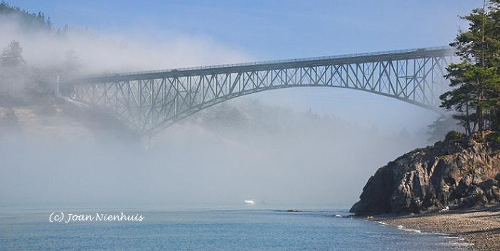
I was at the top of Goose Rock, in the Deception Pass State Park, around 1 pm. While the fog had lifted inland, towards the San Juan Islands the fog was thick. I was taken with how the fog swirled around Deception Island.
A few hours later this was Deception Island as seen from the Deception Pass Bridge.
A few hours later this was Deception Island as seen from the Deception Pass Bridge.
Friday, August 19, 2011
Thursday, August 18, 2011
Wednesday, August 17, 2011
Sunday, August 14, 2011
Saturday, August 13, 2011
Friday, August 12, 2011
Thursday, August 11, 2011
Tuesday, August 9, 2011
Double Bluff, Whidbey Island
This state park is located southwest of Freeland on Whidbey Island. When the tide is out the Useless Bay Tidelands are hundreds of feet wide. The 24,354 foot stretch of beach includes a two mile long Double Bluff Beach Off-Leash Area. Double Bluff has stunning views of Mt. Rainier, the Seattle skyline, the Olympic Peninsula, and shipping lanes. The park includes a picnic area, viewing benches, rest rooms and a rinse station.
This is the view from Lancaster Road, about a mile from the beach.
In both of these photos, one can just barely see the Space Needle on the horizon at the right edge of the scene.
This is the view from Lancaster Road, about a mile from the beach.
In both of these photos, one can just barely see the Space Needle on the horizon at the right edge of the scene.
Friday, August 5, 2011
Red Tide, Freeland, Whidbey Island
I had heard of "red tide" but this was my first time seeing it. These photos are from the boat launch and park at Freeland. I was amazed but the locals said it happens a few times a year.
The "red tide" is the common name for an algal bloom. The algae acummulate rapidly and contain photosynthetic pigments that vary in color from green to red.
The "red tide" is the common name for an algal bloom. The algae acummulate rapidly and contain photosynthetic pigments that vary in color from green to red.
Subscribe to:
Comments (Atom)


