
Photographic images near Whidbey Island, Washington, U.S.A.
Sunday, June 30, 2013
Evening Clouds
Saturday, June 29, 2013
Super Moonrise

Friday, June 28, 2013
Flying by the Olympics

Thursday, June 27, 2013
A Boat So Small

"Oh God, thy sea is so great, and my boat is so small."
I took this photo at Ft. Ebey State Park on the west side of Whidbey Island.Wednesday, June 26, 2013
Whidbey Island Sunset

Monday, June 24, 2013
Crowd for a Sunset


Sunday, June 23, 2013
(Not so) Super Moonrise

Saturday, June 22, 2013
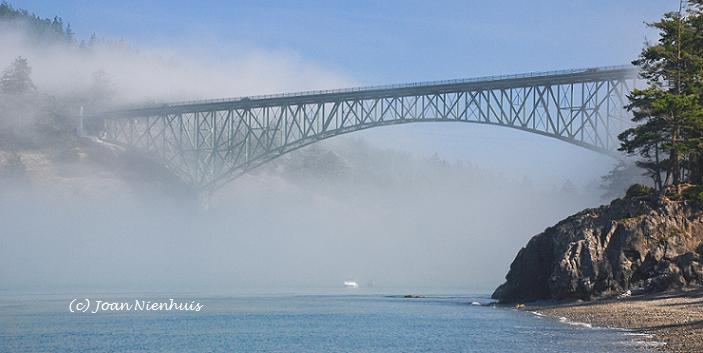
Deception Pass Bridge

Monday, June 17, 2013
San Juan Sunset


These photos were taken at Joseph Whidbey State Park on the west side of Whidbey Island.
Sunday, June 16, 2013
Sun Pillar Sunset


 It remained visible for some time after the sun set. These photos were taken at the Joseph Whidbey State Park on the west side of Whidbey Island. In the first photo above, the islands to the right are the San Juan Islands.
Saturday, June 15, 2013
Sugar Loaf Trail, Fidalgo Island


 The wild flowers were in bloom.
The trail was about 0.5 miles round trip with an elevation gain of 320 feet. If you really want a workout, you can begin your hike at the parking lot where Mt. Erie Road originates. That hike is 2.5 miles with an elevation gain of over 800 feet. I preferred the shorter and easier hike and got the same views.

Friday, June 14, 2013
Chuckanut Mountain Views

The views are wonderful, even if trimming a few trees would make them even better. This view is to the north west with the Lummi Peninsula and then the Canadian Cascades.


To the west, below Chuckanut, is Pleasant Bay.
There is a trail near the crest of the mountain that gives views to the east and the North Cascade Mountains.

I followed that trail for a short distance but I was frustrated with the number of trees blocking any clear view. The possibility of more views on that trail will have to wait for another day.
Thursday, June 13, 2013
Hope Slide

Just a few miles east of Hope, B.C., is the location of the 1965 slide. It was the largest landslide ever recorded in Canada and killed four people.
Wednesday, June 12, 2013
Othello Tunnels
 The Othello Tunnels are near Hope, B.C. at the Coquihalla Canyon Provincial Park.
 There are five tunnels and a series of bridges connecting them that run along an old railroad grade. The tunnels were made between 1911 and 1916, without modern machines.

Several movies have been filmed here, including Rambo: First Blood.

The relatively short and very level trail to the tunnels runs beside the Coquihalla River.
Tuesday, June 11, 2013
Hope, B.C.


It borders the con-fluence of the Coquihalla and Fraser Rivers.

The town is known for its chainsaw carvings, located at intersections and in the park.


A chainsaw carving competition will be held in late summer.
Monday, June 10, 2013

Sunday, June 9, 2013
Mt. Baker and Lynden Area Farmland

Saturday, June 8, 2013
Sunset Picnic

This was the sunset last night. The sun is setting over Vancouver Island in this view from Joseph Whidbey State Park on the west side of Whidbey Island.
Friday, June 7, 2013
Mt. Baker from Lummi Reservation

Thursday, June 6, 2013

Wednesday, June 5, 2013


Tuesday, June 4, 2013
Iris (Flags)


Monday, June 3, 2013

Sunday, June 2, 2013

Saturday, June 1, 2013

Subscribe to:
Comments (Atom)